The Battle of Tewkesbury

“The Kynge apparailed hymselfe, and all his hooste set in good array; ordeined three wards; displayed his bannars; dyd blowe up the trompets; commytted his caws and qwarell to Almyghty God, to owr most blessyd lady his mothar, Vyrgyn Mary, the glorious martyr Seint George, and all the saynts; and advaunced, directly upon his enemyes; approchinge to theyr filde, which was strongly in a marvaylows storng grownd pyght, full difficult to be assayled.” The Arrivall
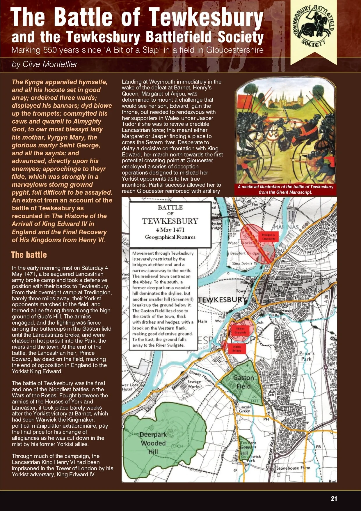
Illustration of the Battle of Tewkesbury from the Ghent Manuscript
In the early morning mist on Saturday 4 May 1471, the Lancastrian army broke camp and took a defensive position with their backs to Tewkesbury. The Yorkist army marched to the field, and formed a line facing them along the high ground of Gub’s Hill. The armies engaged, and the fighting was fierce among the buttercups in the Gaston field until the Lancastrians broke, and were chased in hot pursuit into the Park, the rivers and the town. At the end of the Battle, the Lancastrian heir, Prince Edward, lay dead on the field, marking the end of opposition in England to the Yorkist King Edward.
There are many sites associated in chronicles, literature and local tradition with the events of The Battle of Tewkesbury. There are also locations in Tewkesbury which interpret the battle and the period to the public.
Time has changed many features of the landscape, but not yet made it unrecognizable, nor made it impossible to follow the main manoeuvres of the battle or its aftermath.
At the Western edge of the battlefield can be found the remnants of the Gaston Field, where the Duke of Somerset, the Lancastrian Commander, engaged the Duke of Gloucester and The Park, from which two hundred ‘spears’ charged into the fray, and into which defeated Lancastrians fled. Along with The Bloody Meadow, traditionally the scene of greatest slaughter, these all remain, and despite changes wrought by time they retain their essential character.
The Gaston Field has been identified as the Battlefield. The Gaston Field was the open field to the south of Tewkesbury, probably pasture by the late middle ages. By the end of the seventeenth century it had been divided into seven enclosures. In the eighteenth century, a turnpike road was constructed through it; the present Gloucester Road. In the nineteenth century, there was some ribbon development along the turnpike, and Abbots Road became an exclusive residential area in the 1920s. The Town Cemetery was established in the North East. After the second World War, the land to the east of the road was heavily developed. In the nineteen seventies, development of the north of the field took place; a new road to Tewkesbury Park giving access to enable the development of the Council offices on Windmill Hill and the Battle Road estate on the northern Gastons.
For more information, see the Battlefields Trust resource centre.
Key to meeting our aims is protecting the Battlefield itself and promoting interpretation on site. Our regular walks mean that we are constantly monitoring the condition of the various surviving elements of the Battlefield and every Spring we carry out a full clear-up, removing litter and cutting back the scrub which can impede access. We also work closely with the owners of the Battle sites – mainly the Borough Council and Tewkesbury School – we hope one day to create a visitors centre on the Gaston Field – but that’s another project!
The Battle of Tewkesbury and the Battlefield Society
This article to commemorate the 550th anniversary of the battle appeared in the spring 2021 issue of Battlefield, the magazine of the Battlefields Trust and is reproduced here with their permission.